-Staff Writer / 27, Thu Nov 2025
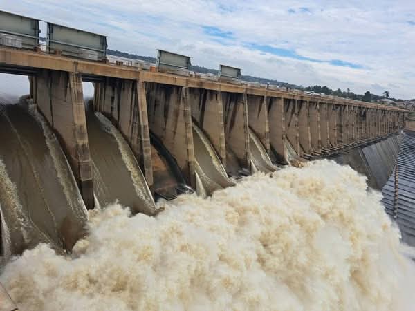
The Klerksdorp-based Matlosana Local Municipality in the North West has issued an urgent flood warning to residents living in downstream and low-lying areas along the Vaal River, following a significant increase in water levels on Thursday, 27 November 2025.
According to the municipality’s spokesperson, Ntswaki Makgetha, ten sluice gates were opened on 27 November 2025, resulting in strong water overflow and a rapid rise in the river’s levels.
Residents in communities situated along the riverbanks, including parts of Orkney near Kanana outside Klerksdorp have been advised to remain on high alert for potential evacuation should conditions worsen.

Makgetha said the Disaster Management Team would be monitoring the situation closely throughout the rainy season. “We urge residents in affected areas to exercise extreme caution and to report any emergencies immediately. The City of Matlosana Fire and Rescue Department’s Control Room can be reached at 018 464 2222 or 018 462 2222 for emergency assistance, ” she said.
The municipality said updates will be issued as conditions change.
Meanwhile, the South African Weather Service (SAWS) has since issued multiple severe weather alerts for Friday, 28 November 2025, warning of widespread thunderstorms, heavy downpours, damaging winds and heightened fire danger conditions across several regions of the country.
The forecast, released at 16:00 on Thursday, highlights a Yellow Level 4 warning for severe thunderstorms over most parts of Limpopo (excluding the extreme north-east) and Mpumalanga (excluding the far south-west). These storms are expected to bring heavy rainfall, localised flooding of roads and low-lying bridges, damaging winds and small hail.
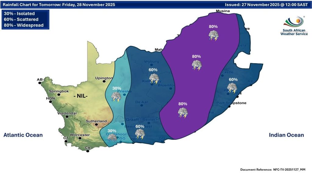
A Yellow Level 2 alert has also been issued for the Free State, south-western North West and the central Eastern Cape, where severe thunderstorms may lead to localised flooding and large amounts of small hail.
Along the coastline between Table Bay and Plettenberg Bay, a Yellow Level 1 warning has been issued for damaging winds in the early morning, posing difficulties for sea navigation.
SAWS further warns of extremely high fire danger conditions across large parts of the Northern Cape, north-eastern Western Cape, north-western Eastern Cape and North West.
Provincial Forecasts
Gauteng:
Cloudy and cool conditions are expected, with widespread showers and thundershowers. UVB sunburn index: Moderate.
Mpumalanga:
Cloudy and cool with widespread showers and thundershowers, becoming scattered over the Lowveld where it will be warm in places.
Limpopo:
Cloudy and cool to warm with widespread showers and thundershowers throughout the province.
North West:
Partly cloudy and cool to warm with scattered showers and thundershowers, becoming widespread in the eastern areas.
Free State:
Partly cloudy and cool to warm, with widespread thundershowers, especially in the east under cloudy conditions.
Northern Cape:
Fine in the west, otherwise partly cloudy and hot to very hot. Isolated showers and thundershowers are forecast for central parts, becoming scattered in the extreme east.
Coastal winds will blow moderate to fresh north-westerly.
Western Cape:
Cloudy and warm along the west and south coasts in the morning and evening; otherwise partly cloudy, hot to very hot with isolated afternoon thundershowers in the extreme east.
Coastal winds will be strong to near-gale easterly to south-easterly in the morning, later becoming moderate to fresh north-westerly to westerly, and fresh to strong south-westerly by evening.
UVB sunburn index: Very High.
Western Half of Eastern Cape:
Very hot conditions over some interior areas, otherwise partly cloudy to cloudy and warm to hot with widespread showers and thundershowers.
Coastal winds: fresh to strong easterly.
Eastern Half of Eastern Cape:
Partly cloudy and warm to hot with scattered thundershowers, becoming widespread in the north-west.
Coastal winds: fresh to strong north-easterly.
KwaZulu-Natal:
Morning fog patches expected over the interior, followed by cloudy and cool to warm conditions with scattered thundershowers.
Coastal winds: moderate easterly to north-easterly, strengthening by afternoon.
UVB sunburn index: Moderate.
SAWS said it will issue an updated forecast at 05:00 on Friday.
News Junction (Gold Standard)